Ranging in surveying is an important concept surveyors use to determine distances between survey marks on the ground or above it. Due to limitations of survey instruments, surveyors are in need to use intermediate points. That’s where ranging technique in survey comes in to play.
There are two types of ranging methods – direct ranging and indirect ranging. Your selection of ranging method depends on factors such as topography and visibility. Anyhow, both these techniques are pretty helpful to accurately undertake survey between intermediate survey marks.
Here’s more information about how each type of ranging works so you can decide which method would be best for your next surveying project.
Why you need to range in surveying?
Survey is the art of determining relative position of object on the surface of earth or beneath with the help of different instruments. It is the first phase to complete before start of any construction project. Surveying in construction includes technique of establishing points by the help of angular or linear measurements.
Main goal of surveying is to prepare plan, section or a map of site than do alignment, levelling, and contouring on plan and practical site by using various surveying instruments like total station, theodolite, compass, GPS, etc., Thus, surveying is the backbone of every type of construction projects like railway, highway, tunnel, building, dam construction, etc.,
Also Read: Difference between Plane Surveying and Geodetic Surveying
What is ranging in surveying?
Ranging in surveying is the method of fixing intermediate points on the survey line. Consider, survey line is to establish between two points. If length of survey line is less than the length of chain, it can be easily determined with the help of chain without intermediary survey point.
However, if length of survey line is far more than the length of chain, then it is difficult to determine the distance at once. Therefore, you need to establish intermediate points along the survey line using ranging rod or pole that will assist you while determining length of survey line. This process of determining length that is far more than length of chain is known as ranging.
Methods of Ranging:
This process of ranging is carried out by using two methods.
- Direct Ranging
- Indirect Ranging
These two methods of ranging are described below.
Direct Ranging:
If you’re thinking about surveying a piece of land for a new house or other structure, it’s likely that you’ll need to use some sort of ranging instrument to determine how far away distant points are. And while that might sound like an elaborate process, ranging by eye isn’t hard at all. In fact, it’s as simple as knowing your angles!
It is the method of ranging a survey line that is only helpful when end points are inter-visible. This method is carried out by eye or instrument called line ranger.
-
Ranging by Eye:
As the name suggests, ranging by eye is pretty helpful when both the main survey stations are visible to the eyes of the surveyors.
Suppose A and B are two end points of survey line that are far more in length than the length of chain. In order to determine length of this survey line direct ranging method by eye will be used where surveyor will ask assistant to place intermediate point by rod on the survey line. He will assist helper to fix intermediate point by asking him to move left or right until this ranging rod come exactly on the main survey line. In this way intermediate points will be fixed on main survey line.
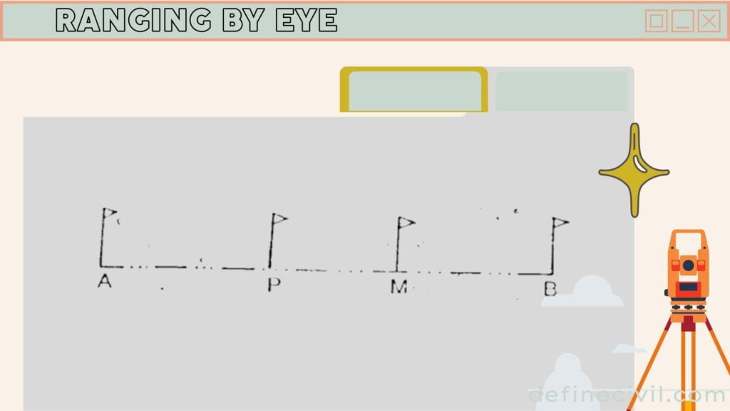
As you’re using chaining survey, make sure the distance between intermediate survey stations is not greater than the length of chain. You can increase the number of intermediate survey stations to ensure such a requirement.
Also Read: Digital Level Surveying – Advantages – Component – Types
-
Ranging by line ranger:
Line ranger is an instrument that makes ranging pretty easy. It helps you directly fix the intermediate points without going for hit and trial. Line ranging is also a method of direct ranging that means it will also be helpful if both the survey stations are visible with naked eye but are far more in distance.
It is the direct method of ranging in which instrument called line ranger is used. This instrument consists of two plane mirrors or prisms that are placed over one another, and it works on the principle of light reflection. These days, line rangers with isosceles prism are more common.
In this method, Surveyor will stand between two points A and B for which he has to fix intermediate pole, he will use line ranger and fix intermediate point whereby the principle of line of reflection both points A and B are visible.
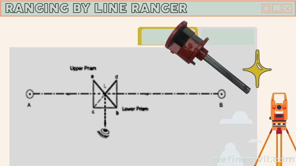
The surveyor can see both the end survey stations with the help of rays coming from the points through prism – upper as well as lower. However, initially the images of ranging rods may not come in same vertical line. So, the surveyor might have to move the line ranger in such a way so the two images lie in the same vertical line.
At the end, you can transfer the point on the ground with the help of an instrument called plumb bob.
At this stage, you can easily conclude that ranging by line ranger is more accurate than by direct eye.
Indirect Ranging
It is method of ranging which is employed when end points of survey lines are not visible. Following procedure is employed for indirect ranging:
Suppose A and B are two points that are not visible to each other, and intermediate points will be fixed in such a way that two surveyors with ranging rod will stand at point M1 and at point M2. Now, the surveyor standing at point M2, will ask the surveyor at M1 to change the position and employ new position M3 such that point M2-M3-A are on same line.
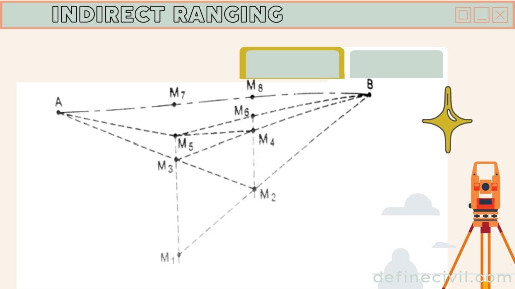
Similarly, now surveyor standing at new position M3 will ask the surveyor at position M2 to change its position and come to new position marked as M4 such that point M3-M4-B are in same line.
This procedure is adopted till intermediate points between line A and B is fixed which is shown by point M7 and M8.
Also Read: [PDF] Download Surveying Leveling Books Free (22.5 MB Files)
Application of ranging
Modern surveyors use distance measuring equipment (DME) to determine range distances and GPS to record locations. However, you can also estimate ranges by line ranger (or line of sight ranging) and ranging by eye if you don’t have access to DME or GPS. When ranging by line ranger, you are still using trigonometry, but instead of using algebraic equations, you’re looking at two sides of a triangle with your eyes.