Just like any other field, civil engineering has been revolutionized by modern management, planning, designing, modeling, and collaboration software. Civil Engineering software list can include massive number of such applications. But being a student or even in professional field you must know the use of software relevant to your field of interest or expertise.
During my times of graduation, I was literally advised countless times by my seniors and mentors to get yourself familiarize at least with some basic and essential software programs like AutoCAD, AutoCAD Civil 3D, Microsoft Project, Primavera, WaterCAD, EPA-Net, and Bluebeam.
But if you’re a newbie you won’t be able to even recognize their name; that’s where this guide comes handy. I’ve tried my best to utilize my years of experience in field of practical civil engineering to help you understand some basics of civil engineering software.
We’ll see what these software are capable of and what are some of their applications. So, let’s get started:
Role of software in civil engineering
Civil engineering is a field that involves the application of different disciplines such as physics, chemistry, structural engineering, and others.
Civil engineers use various software, tools, and applications to design, plan, and track project execution for various relevant works like buildings, roads, bridges and other structures for public use. They also design dams, tunnels and other large-scale projects.
Civil engineers are responsible for planning construction projects like building new schools or hospitals or designing office buildings. They also assess risks involved in construction projects like determining the strength of concrete or steel beams required to build a structure.
Civil engineers must consider the impact of environmental factors on society, economic costs and benefits, technical feasibility and safety when making decisions.
Civil engineering deals with the design, construction, and maintenance of built infrastructure and public works. It applies a variety of methods, including civil engineering science, to achieve these goals.
These methods are often referred to as practices or methodologies. Civil engineers usually study in schools of engineering which specialize in this field such as structural engineering, transportation engineering or construction engineering.
The practice of civil engineering includes dealing with public issues such as water supply management and waste management.

Most Commonly used Software in Civil Engineering:
Some the most commonly used software in construction industry are as follows:
- Autodesk AutoCAD
- ETABS
- Primavera P6
- MS EXCEL
- SAP 2000
- ArcGIS
Here’s a summary and the software list:
| Serial Number | Software Name | Main Field of Application | Summary of Applications |
| 1 | Revit | Building Information Modeling (BIM) | Building design and documentation, Site planning and design, Road and highway design, Stormwater management, Water and waste management, Earthworks and grading, Building Services |
| 2 | SAP2000 | Finite Element Analysis and Design | Structural analysis and design, Linear and nonlinear analysis, Dynamic analysis, Concrete and steel design, Cable and tension membrane structures, Foundation design, Pavement analysis and design, Advanced modeling |
| 3 | ArcGIS | Geographic Information System (GIS) | Site selection and land use planning, Transportation planning, Stormwater management, Environmental monitoring, Natural resource management, Survey and mapping, Emergency management, Fleet management and logistic |
| 4 | ETABS | Finite Element Analysis and Design | Structural analysis and design, Linear and nonlinear analysis, Dynamic analysis, Concrete and steel design, Cable and tension membrane structures, Foundation design, Advanced modeling, seismic analysis and design. |
| 5 | AutoCAD | Computer-Aided Design (CAD) | Construction documents, Site and infrastructure planning, 3D modeling and visualization, Mapping, Surveying, Mechanical design, Electrical and plumbing design, Interior design |
| 6 | Primavera P6 | Project Management and Scheduling | Project planning and scheduling, Resources management, Cost management, Earned value analysis, Risk management, Collaboration and Communication |
| 7 | PlanSwift | Estimation and takeoff software | Quantity takeoff, 3D modeling, On-screen takeoff, Import and export data, Cost and Material Estimation, Reporting and collaboration |
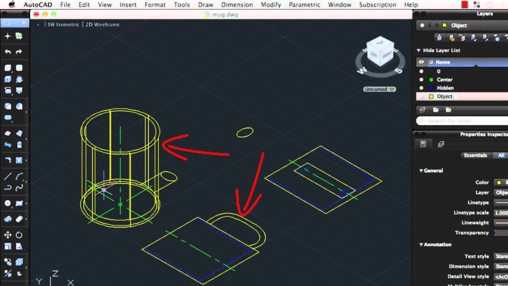
1. Autodesk AutoCAD – Drafting & Designing made easy
Autodesk AutoCAD is one of the most widely used civil engineering design and drafting software program. It is equally popular among engineers, architects, contractors, and designers in the field of civil engineering and other disciplines.
The program can be used to create drawings for construction documents, structural plans, architectural designs, maps and charts.
Here’re some common applications of AUTOCAD in civil engineering
- Site plans and mapping: AutoCAD is commonly used to create detailed site plans, maps, and other survey-related drawings.
- Road design: Engineers use AutoCAD to design and model roads, including the layout of lanes, medians, and intersections.
- Building design: AutoCAD is used to create detailed floor plans, elevations, and sections of buildings.
- Structural design: Engineers use AutoCAD to design and model various types of structures, such as bridges, buildings, and other infrastructure.
- Stormwater management: AutoCAD is used to design and model stormwater management systems, including drainage channels, retention ponds, and other components.
- Sanitary sewer design: AutoCAD is used to design and model sanitary sewer systems, including the layout of pipes, manholes, and other components.
- Water supply design: AutoCAD is used to design and model water supply systems, including the layout of pipes, pumps, and other components.
- Quantity takeoff: AutoCAD can also be used to perform quantity takeoff, which is the process of determining the quantities of materials and labor required for a construction project.
- Building Information Modeling: AutoCAD supports BIM (Building Information Modeling) which allow user to create 3D model that contains detailed information and parametric data of building components and systems.
Anyhow, AutoCAD don’t have built-in structural design capabilities; it just takes the output of structural design software to draft shop and construction drawings.
Autodesk AutoCAD has been developed by Autodesk Inc., a company based in Carlsbad California. The company was founded in 1982 as an independent developer of computer-aided design (CAD) software for the architecture industry.
Autodesk AutoCAD 3D CAD design and drafting program is used for creating, editing, and visualizing technical drawings of buildings, machines, and other objects. The program has been developed over the years to meet the needs of engineers and architects who need to create 3D models of their designs in order to communicate them with clients or build supervisors more effectively.
Also Read: Benefits of CAD software for civil engineers
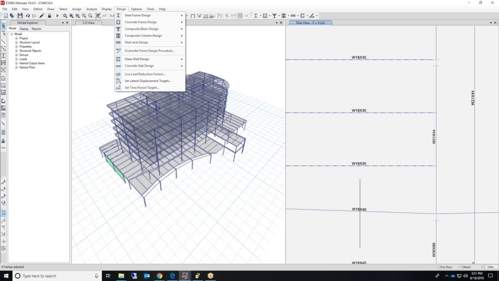
2. ETABS – Structural modeling, analysis and design made simple
ETABS (Extended Three-dimensional Analysis of Building Systems) is the most popular building structural modeling software. It is quite popular because of enhanced structural analysis and designing capabilities. This software is very handy and user can model and analyze structures with a very friendly graphical mode.
Users can adjust and play with the software using editor’s mode. Moreover, it helps with understanding the static and dynamic analysis of shear wall building and multi-story structures.
Here’re some applications for ETABs in Civil Engineering:
- Building Analysis and Design: ETABS is a software used for the structural analysis and design of buildings, allowing engineers to model and analyze both linear and nonlinear behavior of a structure.
- Concrete and Steel Design: ETABS has the capability to perform design of reinforced concrete and steel members in compliance with various international design codes.
- Frame and Finite Element Analysis: The software can perform both frame and finite element analysis, allowing engineers to model a structure’s behavior under various loads and boundary conditions.
- Seismic Analysis and Design: ETABS has features for seismic analysis and design, which allows engineers to evaluate a building’s response to earthquakes and other seismic events.
- Modal Analysis: ETABS can perform modal analysis, which is used to determine the natural frequencies and mode shapes of a structure.
- Time-history analysis: It has the capability to analyze the nonlinear dynamic behavior of structures under different loading conditions
- Wind Load Analysis: ETABS can also perform wind load analysis, which is used to evaluate a building’s response to wind loads.
- P-Delta Analysis: It also can perform second order analysis (P-Delta analysis) which determine the effects of load induced deformations on the structural behavior
- Cable-Stayed and Suspension Bridges: ETABS has the capability to model and analyze cable-stayed and suspension bridges, anyhow for advanced bridge designs designers use CSI Bridge software.
3. Primavera P6 – for all you planning and project management needs
If you’re ever thought of becoming a planning engineering, Primavera P6 must be your favorite. This Oracle Primavera P6 is used in construction industry to create project schedules, planning, monitoring, budgeting, risk cost analysis, and forecasting of a project.
In short, Primavera P6 is a planning and a construction management tool which is used to track the progress of a project.
In P6 we can make baseline for our project by assigning activities and then then by giving them duration, we can determine the completion date of our project.
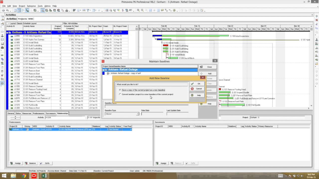
If things don’t go as we planned, then we can simply create a recovery plan for our project to meet the deadline. It is very helpful in managing any project and keeps thing in motion.
As we know, Planning engineers are involved in a wide range of activities that includes transportation planning; structural design; geotechnical engineering; environmental management; structural repair and maintenance; dam and reservoir construction; water supply systems development; disaster mitigation measures, therefore P6 can be a very effective tool as far as planning is concerned.
Also Read: Importance of Technology in Architecture
Here’re some applications of primavera:
Resource management: Primavera can be used to track and manage the allocation of resources such as labor, equipment, and materials.
Scheduling: The software can be used to create detailed project schedules, including critical path analysis and resource leveling.
Cost management: Primavera can be used to track project costs and budgets, and to generate cost reports.
Risk management: The software can be used to identify potential risks and to create risk management plans.
Progress tracking: Primavera can be used to track the progress of a project, including the completion of tasks, and to generate progress reports.
Collaboration: Primavera in a network-based platform, allow multiple stakeholders who can access, view, and update the project information from different location.
Integration: The software can be integrated with other tools, such as BIM and GIS, to provide a more comprehensive view of the project.
Tracking performance: it allows collecting data on labor, equipment, and material usage to improve future project planning and estimate.
Also Read: Using Innovative Technologies to succeed in Construction
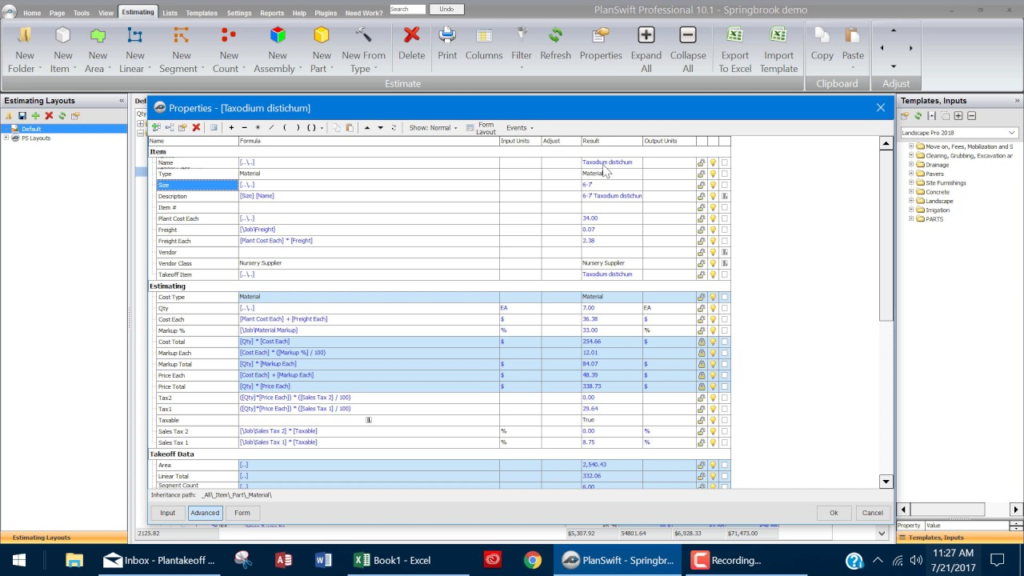
4. MS EXCEL and Plan Swift for estimation and cost management
If you want to become a quantity surveyor, estimation engineer, or cost control engineer; you need to love the combo of Plan Swift and MS Excel. Plan Swift is basically an advanced version of simple PDF viewer.
It allows you to manage drawings, plans, and sections from where you can extract quantities and do takeoffs with just a few clicks. You just need to set the scale and boom! Just highlight the area and it’ll give you the area, length, width, and height.
Also Read: Construction Estimation – Process – Tips for Accurate Estimates
You can extract the takeoff data from Plan Swift to prepare BOQ, tender documents, Bids, and any other estimate. When it comes to calculation, graphing tools, pivot tables, and a macro programming language, MS Excel is at the top in its league.
You can also use MS Excel to handle and manage massive textual data. It can be your database for logs of correspondence, site reports, activity progress reports, and so on.
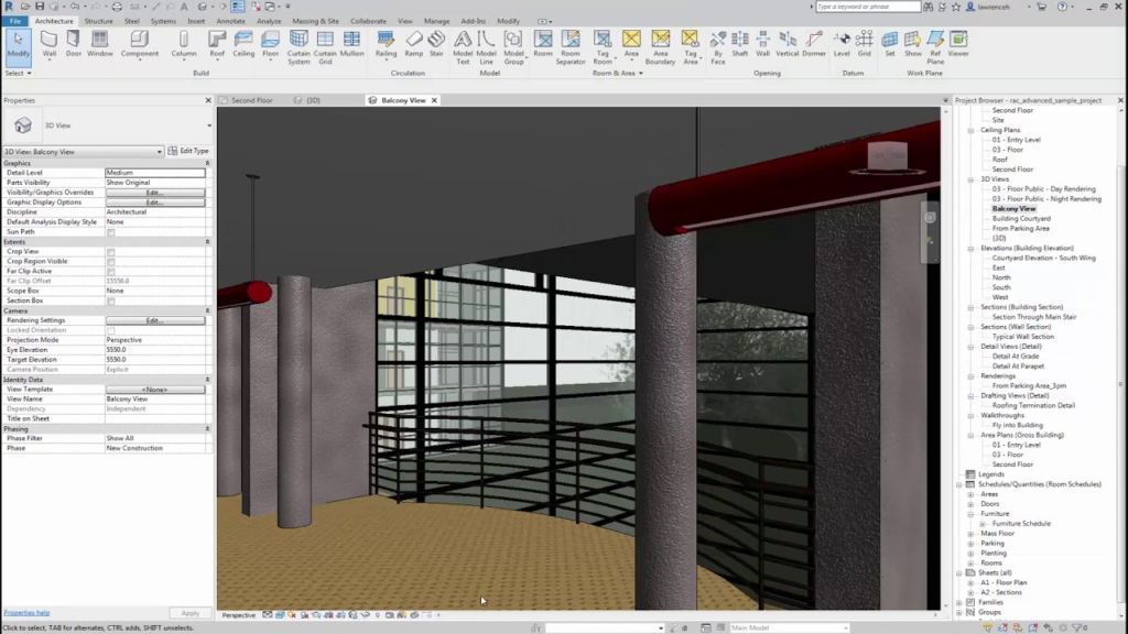
5. REVIT
REVIT is booming these days for its application in Building Information Modeling. It is used to create 3D visual representations of buildings and other structures. It is a complete design tool for architects, interior designers, engineers, structural consultants and others who work in the building design field.
It allows users to create three-dimensional models of buildings from floor plans or elevations. Revit Architecture has many features that make it ideal software for designing and modelling buildings.
This software has a wide range of tools that allows the user to model any type of structure with ease. It has many features such as the ability to import different types of data, create and modify views, and export the model in various formats. The program also has an intuitive user interface that makes it easy for anyone to use.
Building design and documentation: Revit can be used to create detailed 3D models of buildings and other structures, including the placement of walls, floors, roofs, and other components. These models can be used to generate detailed construction drawings and documentation.
Also Read: The 5 Best Construction Apps to Boost Productivity in 2022
Site planning and design: Revit can be used to design and model the layout of a site, including the placement of buildings, roads, sidewalks, and other features. This can help civil engineers to visualize and optimize the use of space on a site.
Road and highway design: Revit can be used to design and model roads, highways, and other transportation infrastructure. This can help civil engineers to plan and design transportation systems that are safe and efficient.
Stormwater management: Revit can be used to model and analyze stormwater systems, such as drainage networks and retention ponds. This can help civil engineers to design systems that effectively manage and control stormwater runoff.
Water and waste management: Revit can be used to design and model water and waste management systems, such as sewage treatment plants, water distribution networks and water storage tanks. This can help civil engineers to optimize the performance of these systems.
Earthworks and grading: With Revit’s Civil extension and other add-ons, Civil Engineers can model terrain and conduct earthworks analysis, as well as design grading plans for sites.
Building Services: Revit can also be used to model and analyze building services like plumbing, HVAC, and electrical systems, allowing for better coordination and coordination of those systems with architectural and structural elements
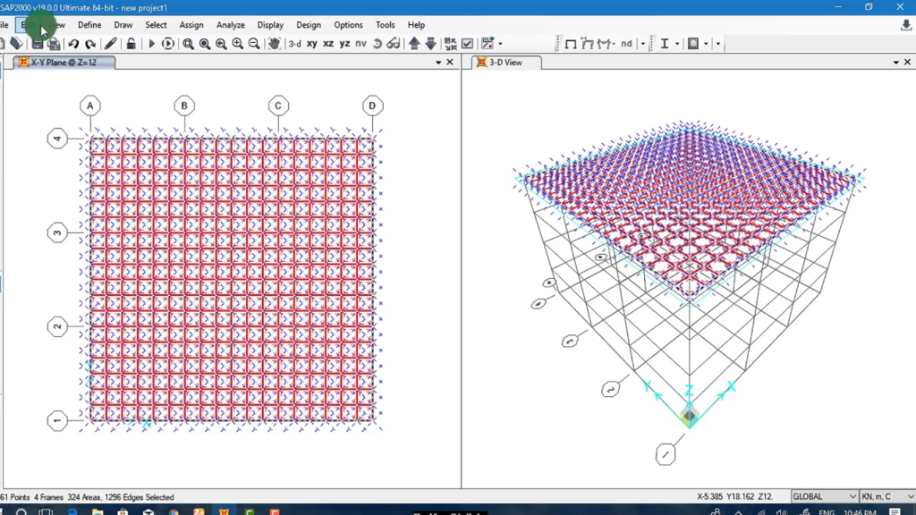
6. SAP 2000
Sap2000 is a civil engineering software which can be used for the analysis and design of any type of structural system, Including multistoried buildings, stadiums, towers, industrial plants, offshore structures, piping systems, skyscraper.
It provides a wide range of tools for planning and designing such structures. It has various features such as 3D visualization with realistic visualization and animation techniques to enable users to see the structure in its actual form before its fabrication.
It also provides a wide range of capabilities to perform such tasks as designing and building bridges; calculating loadings on members, calculating shear force on members, and calculating deflection of members under static loads.
- Structural analysis and design: SAP2000 can be used to analyze and design a wide range of structures, including buildings, bridges, and other types of civil engineering projects. This includes analyzing and designing the structure for different load cases, such as dead loads, live loads, and wind loads, to ensure safety and stability.
- Linear and nonlinear analysis: SAP2000 can be used to perform both linear and nonlinear analyses of structures. Linear analysis is used to predict the behavior of structures under normal loads, while nonlinear analysis is used to predict the behavior of structures under extreme loads or when the structure is likely to experience significant deformation.
- Dynamic analysis: SAP2000 can be used to perform dynamic analyses of structures, such as vibration analyses and seismic analyses, to determine the response of the structure to dynamic loads such as earthquakes and wind.
- Concrete and steel design: SAP2000 can be used to design concrete and steel structures, such as beams, columns, slabs and walls, according to various design codes and standards.
- Cable and tension membrane structures: The software allows the engineer to design and analyze cable and tension membrane structures, such as suspension bridges, cable-stayed bridges, and tensile structures.
- Foundation design: The software features soil-structure interaction, which allows the engineer to design foundations of various types and geometries, from shallow foundations to deep foundations and piles.
- Advanced modeling: the software can handle advanced modeling like non-prismatic beams, shear walls with openings and non-uniform sections.
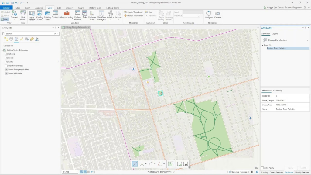
7. ArcGIS
ArcGIS is a powerful platform for analyzing and visualizing data. It has a vast array of tools that can be used to perform analysis on spatial data, such as maps, tables, and charts.
These tools are available in the desktop version of the software as well as in the web-based version. The ArcGIS platform provides powerful capabilities for managing and analyzing large amounts of spatial data.
The platform includes an extensive set of tools that can be used to analyze different types of spatial data including maps, tables, and charts. The ArcGIS platform has been designed to work across multiple devices and platforms, including desktop computers as well as mobile devices such as smartphones and tablets.
This makes it possible for users to access the platform from any location at any time without having to worry about connectivity issues or device compatibility issues.
Some applications of ArcGIS in civil engineering are:
Site selection and land use planning: ArcGIS can be used to analyze spatial data, such as satellite imagery and elevation data, to identify suitable locations for new development or infrastructure projects. This information can be used to plan land use and manage resources efficiently.
Transportation planning: ArcGIS can be used to create digital maps of transportation networks, including roads, railways, and airports. This information can be used to analyze traffic patterns and identify areas of congestion, which can help civil engineers to plan and design efficient transportation systems.
Stormwater management: ArcGIS can be used to create digital maps of stormwater systems, including drainage networks, retention ponds, and other features. This information can be used to analyze and manage stormwater runoff, helping to reduce the risk of flooding and erosion.
Environmental monitoring: ArcGIS can be used to analyze spatial data to identify and monitor potential environmental hazards, such as air and water pollution. This information can be used to plan and design mitigation measures to protect public health and the environment.
Natural resource management: ArcGIS can be used to map and analyze natural resources, such as forests, minerals, and water resources, to help plan and manage their use.
Survey and mapping: ArcGIS can be used to analyze, process and map survey data, such as aerial imagery, LiDAR, GNSS and total stations. This can help civil engineers and surveyors to create accurate maps, diagrams, and 3D models of the built and natural environment.
Emergency management: ArcGIS can be used to create digital maps of emergency response infrastructure, such as fire stations, hospitals, and evacuation routes. This information can be used to plan and coordinate emergency response efforts, helping to protect public safety during natural disasters and other emergencies.
Fleet management and logistic: ArcGIS can be used to track, monitor and optimize the movement and maintenance of fleet of vehicles, trucks and equipment, as well as logistic processes such as delivery and inventory tracking.
These are just a few examples of how ArcGIS can be used in civil engineering, the software capabilities are vast and it can be integrated with many other tools, making it a powerful tool for various industries, including infrastructure management and planning.