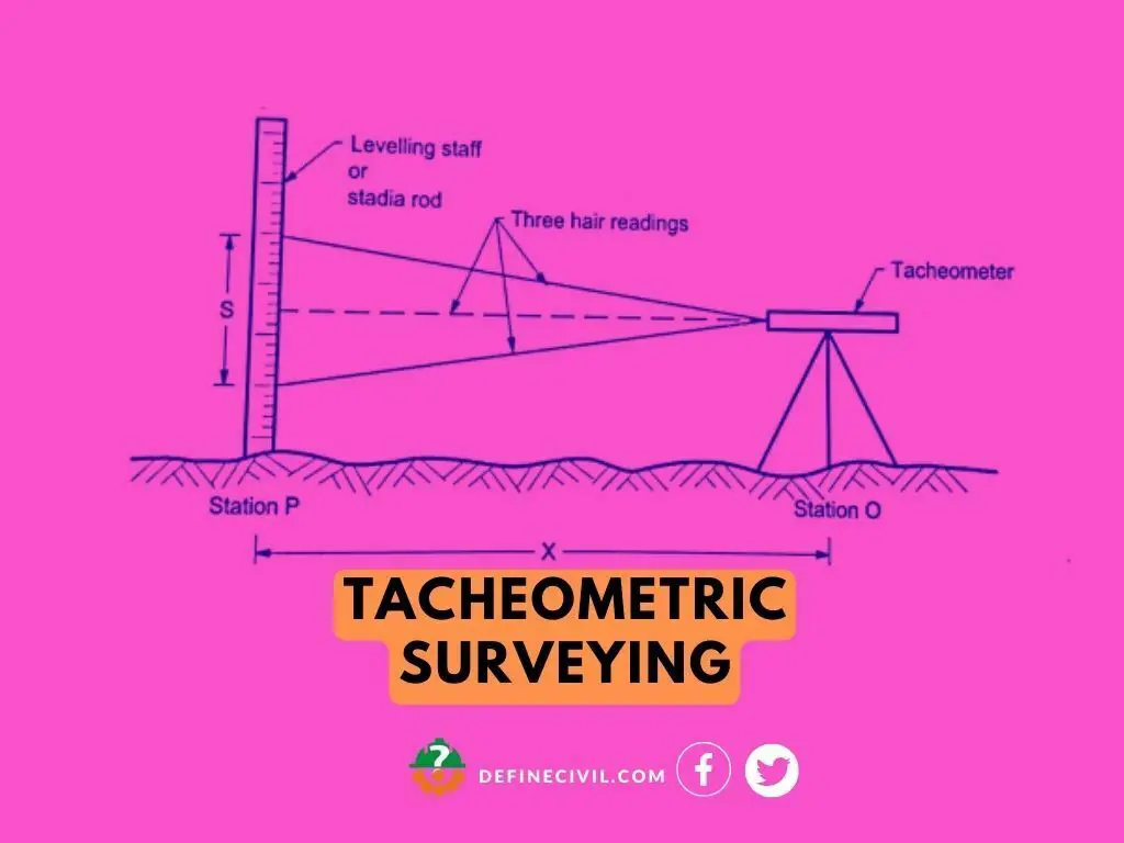
A tacheometric surveying is a branch of surveying in which we find the horizontal and vertical position of point on earth surface with the help of tacheometer. In this type of surveying there is no need of chain or tape for distance measurement and separate level for the measurement of elevation. In general sense, a tacheometer is a transit theodolite, and it has stadia telescope which has two horizontal hairs called stadia hairs.
Tacheometric surveying is done for locating contours, for hydrographic surveys, for filling detail in topographic surveys and location surveys of roads and rails
This type of survey can be completed very fast because it only involves observation through tacheometry and vertical staff at the point of sight. While chaining or tape is slow, tedious and inaccurate for areas where there is sloping terrain or hilly areas, areas covered with swamps, stretches of water.
We can classify tacheometry as an optical survey unlike typical process of chaining and tape. In conventional surveying methods, surveyor takes liner measurement on the file with the help of tape or chain. (chain surveying and traverse surveying).
Application of Tacheometric Surveying
Some important applications of tacheometric survey are as follows.
- Beneficial for preparing contour maps when vertical and horizontal both distances are required
- Beneficial in triangulation Surveying.
- Useful in areas where with other surveying like plane table becomes difficult to work. So, in those areas’ tacheometry do the same work with ease and with good accuracy.
- Useful to establish secondary control points.
Also Read: Ranging in Surveying – Direct Ranging – Indirect Ranging – Line Ranger [PDF]
Methods of Tacheometric Surveying
There are various methods of tacheometric surveying and it based on the principle that the horizontal distance between instrument station X and staff station Y depends upon the angle subtend at point “X” by known distance at point “Y”.
Two important methods of tacheometric surveying area Stadia hair method and Tangential method.
Stadia System
In a stadia system the horizontal distance between tacheometer station and staff station and staff station elevation concerning the line of sight of instrument is obtained by taking one measurement from tacheometric station.
Stadia system of tacheometric surveying is divided into two types.
- Fixed hair method
- Moveable hair method
Also Read: Difference between Plane Surveying and Geodetic Surveying
Fixed hair method
In fixed hair method the instrument consists of telescope fitted with two additional horizontal cross hairs one above and other below central hair. These two hairs are fixed at equal interval from central hair and these two hairs are also called stadia hairs.in fixed hair method the distance between these two stadia hairs is fixed. In this method when staff is sighted through the tacheometer a certain length of staff will be intercepted by stadia lines and from that staff intercept the distance between tacheometer and staff will be determined. The staff intercept depends upon the distance between instrument and staff. As we move away from instrument the staff intercept will start increasing. The horizontal distance between staff and instrument vertical axis is found by formula given below.
D=f/I *S+ (f+d)
F=focal length
I=interval between stadia hairs
S=Staff intercept value
D=Horizontal distance from optical Centre to vertical axis of tacheometer.
If the staff intercept is more than the length of staff, then we will read only half an intercept which should be equal to difference between stadia reading and lower or upper stadia reading.
Also Read: Chain Surveying – Principles of Chain Surveying
Moveable hair method
In moveable method of tacheometric surveying the instrument consists of a telescope fitted with stadia hairs which we can move according to a requirement and fixed at any distance from central hair. In this method the staff consists of two targets at fixed distance. The stadia interval is different for different positions of staff and horizontal distance between instrument and staff is measured by observation.
Out of two methods explained above fixed hair method is most used.
Tangential Method
In tangential method of tacheometric surveying two observations from staff station to instrument stations are required. The main purpose of this is to find the horizontal distance and difference in elevation between staff and the line of collimation. One advantage of using this method is that it can be done with ordinary transit theodolite. Ordinary transit theodolites are cheaper as compared to a tacheometer so this advantage will reduce the survey expenses. As far as results are concerned there is not much difference between the readings of elevation and distances obtained by this method. But this method is not preferred due to more accuracy required. The speed of surveying is also reduced in this method due to more observations required.
Errors in Tacheometric Surveying
Instrumental Error
This type of error occurs due to faulty instrument or inaccurate graduations in stadia hairs. Before using the instrument make sure that instrument is working properly.
Manipulation and Sighting Error
This error depends upon the surveyor efficiency and expertise and how much he is attentive while surveying. This type includes centering and levelling error, wrong stadia readings taken by instrument. In order to avoid this error surveyor focus should be completely on survey while taking readings and performing tacheometric survey.
Natural Error
This type of error can also occur while doing survey. It is due to natural causes which are beyond the control of surveyor like expansion of components due to temperature, wind, visibility and unequal refraction.
Also Read: [PDF] Download Surveying Leveling Books Free (22.5 MB Files)
Advantages
- The tacheometric survey is fast and field work can be completed in less time.
- There is no use of chain and tape, and measurement can be taken with tacheometry which saves time and does not make survey work tedious and complex.
- This type of survey can be completed in very less cost.
- The main benefit of this survey is that it can be easily done for locating contour, for hilly areas and for location surveys of roads, rails and reservoirs.
Procedure of Application
- The first step is setting up the instrument. You need to pick a base point and accurately level the instrument in reference with altitude level.
- Once you’re set, we need to measure the height of the instrument. With the altitude level at the center, use meter tape to determine vertical distance between top of the peg to the center of the objective. You can also use stadia rod to read the height out of the object glass.
- Now we need to set the orientation of the instrument with reference to the meridian – true or magnetic. If you’re following true meridian, take true bearing as the reference point, setup the vernier to read the bearing. Now revolve the telescope about the outer axis until that particular station or reference object is visible.
- The next step is taken the bearing and angles. You can ask anyone to hold the staff on the benchmark to note the bearings, vertical angle, top and bottom axial hair readings. Please note that the line of sight can be horizontal or inclined.
- If you don’t have any benchmark nearby, you can establish a temporary benchmark with the help of a fly level.
- Now you’re ready to take side shots. Try to focus all the representative points under the command of the instrument station. You’ll take readings for vertical angles, staff readings – top, bottom, and axial hairs.
- Now, take a foresight at the second station and repeat the process to note down the bearings.
- Shift the instrument to the second station to observe the bearings.
- Now you will repeat the process to sight each station twice to obtain two values of distance and elevations of the stations. If these values are within the permissible limits. If they’re not you’ll need to repeat the work.